Itinerary that allows you to travel further inland and get to know it better even in the winter season. Various testimonies recall the peasant and craft activities that took place not far from the sea (terracing with their dry walls, mills, furnaces, etc.)
The itinerary of the Sentiero delle Terre Alta is divided into six stages that can be walked at different times, taking advantage of the easy connections with the coast.
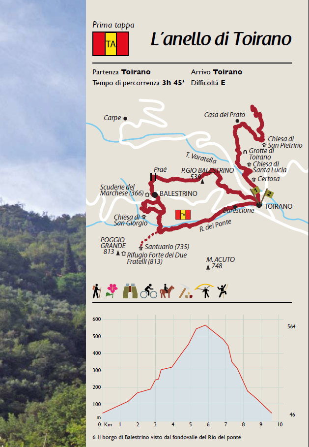
First stop: about 9 km loop - 3.5 hours walk from Toirano to Balestrino (539 m) and back.
Second stage: route of 9.8 km. about - 4.5 hours walk to the refuge of Pian delle Bosse (841 mt). Overnight at the refuge.
Third stage: 15.75 km walk - 7 hours walk to the Colle di Melogno final destination of our excursion through pastures, hazel groves, beech woods, centuries-old chestnut trees, waterfalls and pools of clear water.
Fourth stage: Route from the Colle del Melogno to the Pian dei Corsi about 2.5 hours walk.
Fifth stage: Path that connects Pian dei Corsi to the Colla di San Giacomo.
Sixth stage: Last route that connects the Glue of San Giacomo to Spotorno, a town on the sea near Savona.